If you are searching for the best places to visit in Afghanistan, then you are at the right portal. Here we will tell you which destinations you can visit in Afghanistan and we will also give you a brief of some interesting facts about Afghanistan. It is a land where relics of various empires from history can be seen. It is said to be inhabited 50000 years ago with invasions from the Kuru Kingdom, Mauryan Empire, British Empire, Alexander the Great and Khan.
Afghanistan officially called the Islamic Republic of Afghanistan, is a landlocked country located in South-Central Asia. Afghanistan shares borders with Pakistan in the south and east; Iran in the west; Turkmenistan, Uzbekistan, and Tajikistan in the north; and in the far northeast, China. Kabul is the national capital and political epicenter of Afghanistan. Afghanistan is famous for its pomegranates in Asia.
Currency: Afghan afghani
President: Ashraf Ghani
Population: 3.55 crores (2017 census)
Official languages: Pashto, Dari
Famous Places to Visit in Afghanistan
Kabul - Capital and Largest City in Afghanistan
Kabul is the capital and largest city of Afghanistan, located in the eastern section of the country. It is also a municipality, forming part of the greater Kabul Province. According to estimates in 2019, the population of Kabul is 5.266 million, which includes all the major ethnic groups of Afghanistan. Rapid urbanization had made Kabul the world's 75th largest city. Kabul is located high up in a narrow valley between the Hindu Kush mountains, with an elevation of 1,790 meters, making it one of the highest capital in the world.
The city is said to be over 3,500 years old, mentioned since at least the time of the Achaemenid Empire. It is at a strategic location along the trade routes of South and Central Asia, and a key location of the ancient Silk Road. It has been part of the Achaemenids followed by the Seleucids, Greco Bactrians, Indo Greeks, Kushans, Kabul Shahis, Saffarids, Samanids, Ghaznavids, Ghurids, Khwarazmians, Qarlughids, Khaljis, Timurids, Mughals, and Hotaks until finally becoming part of the Durrani Empire in 1747.
Bamyan - UNESCO Creative Cities Network
Bamyan also spelled Bamiyan or Bamian is the capital of Bamyan Province in central Afghanistan. With an altitude of about 2,550 m and a population of about 100,000, Bamyan is the largest town in the central Afghanistan region of Hazarajat, and lies approximately 240 kilometers north-west of Kabul, the national capital. Many statues of Buddha are carved into the sides of cliffs facing Bamyan city. In 2008, Bamyan was found to be the home of the world's oldest oil paintings.
The city of Bamyan has a population of 100,000. It has four districts and a total land area of 3,539 hectares. The total number of dwellings in this city is 4,435. The Bamiyan valley marked the most westerly point of Buddhist expansion and was a crucial hub of trade for much of the second millennium CE. It was a place where East met West and its archaeology reveals a blend of Greek, Turkic, Persian, Chinese and Indian influence. The valley is one of Afghanistan's most touristic places. Bamyan City joined the UNESCO Creative Cities Network as a Crafts and Folk Art city in 2017. It is also one of the best places to visit in Afghanistan.
Herat - City in Valley of the Hari River
Herāt is the third-largest city of Afghanistan. It has a population of about 436,300 and serves as the capital of Herat Province, situated in the fertile valley of the Hari River in the western part of the country. It is linked with Kandahar, Kabul, and Mazar-i-Sharif via Highway 1 or the ring road. It is further linked to the city of Mashhad in neighboring Iran through the border town of Islam Qala, and to Mary in Turkmenistan to the north through the border town of Torghundi.
Herat dates back to Avestan times and was traditionally known for its wine. The city has a number of cultural sites in Afghanistan, including the Herat Citadel and the Musalla Complex. During the Middle Ages Herat became one of the important cities of Khorasan, as it was known as the Pearl of Khorasan. It has been governed by various Afghan rulers since the early 18th century. In 1717, the city was invaded by the Hotaki forces until they were expelled by the Afsharids in 1729. After Nader Shah's death and Ahmad Shah Durrani's rise to power in 1747, Herat became part of Afghanistan.
Mazari Sharif - Islamic and Hellenistic Archeological Sites
Mazār-i-Sharīf, also called Mazār-e Sharīf, or just Mazar, is the fourth-largest city of Afghanistan, with a 2015 UN-Habitat population estimate 427,600. It is the capital of Balkh province and is linked by highways with Kunduz in the east, Kabul in the southeast, Herat in the west and Termez in Uzbekistan in the north. It is about 55 km from the Uzbek border. The city also serves as one of the many tourist attractions because of its famous shrines as well as the Islamic and Hellenistic archeological sites. The ancient city of Balkh is also nearby.
The name Mazar-i-Sharif means "Tomb of the Prince", a reference to the large, blue-tiled sanctuary and mosque in the center of the city known as the Shrine of Ali or the Blue Mosque. Some people believe that the tomb of Ali ibn Abi Talib, the cousin, and son-in-law of the Islamic prophet Muhammad, is at this mosque in Mazar-i-Sharif after Ali's remains were transferred to Mazar-i-Sharif as per the request of Ja'far as-Sadiq. This is however rejected by other Muslims, as the majority believe he is buried in Najaf, Iraq.

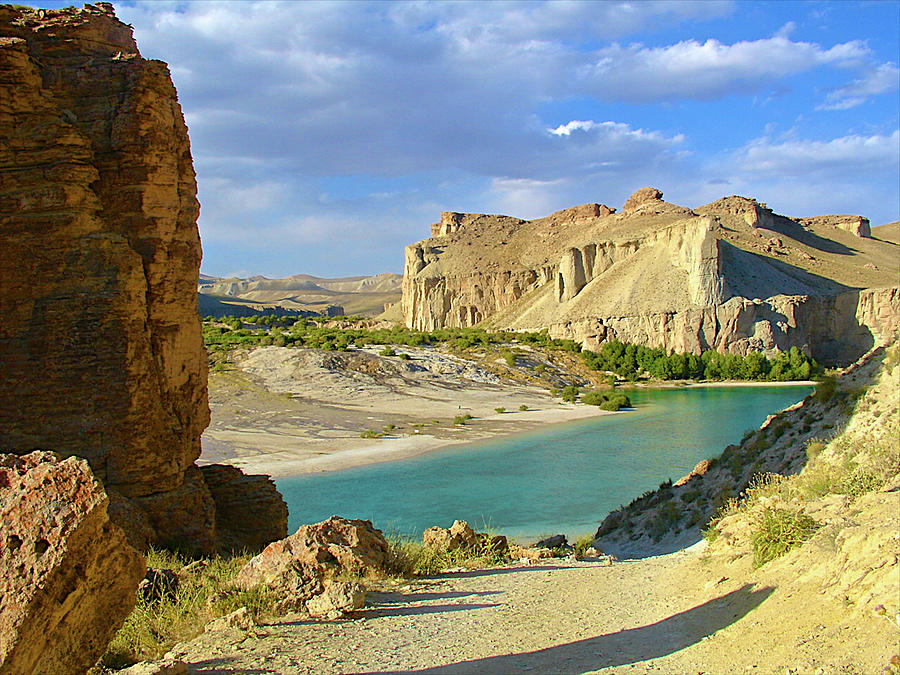
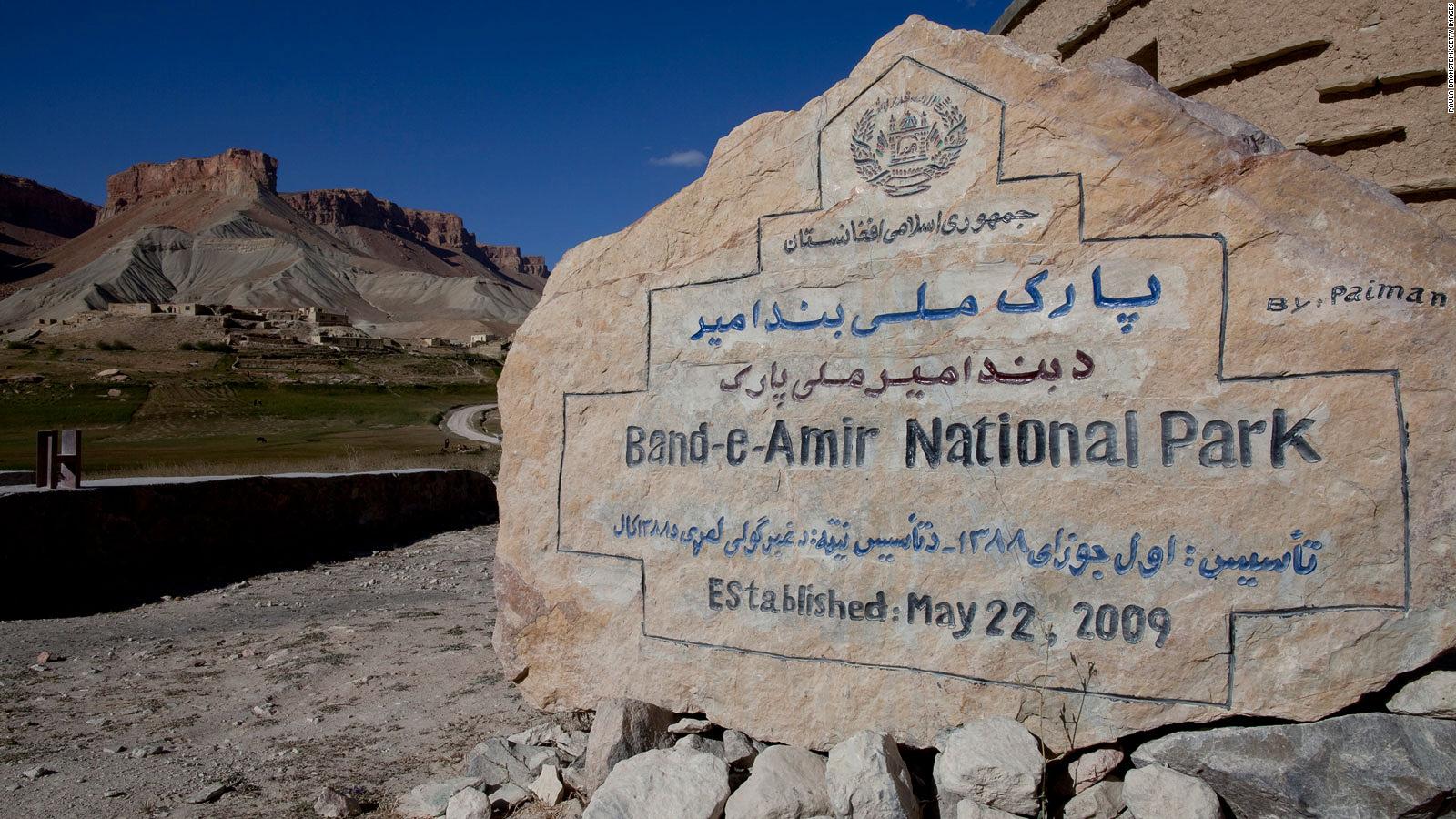
Band-e Amir National Park - Afghanistan's Grand Canyon
Band-e Amir National Park a national park located in the Bamyan Province of central Afghanistan. It is a series of six deep blue lakes separated by natural dams made of travertine, a mineral deposit. The lakes are situated in the Hindu Kush mountains approximately 3000 m of elevation, west of the famous Buddhas of Bamiyan. It is one of the most beautiful places to visit in afghanistan
They were created by the carbon dioxide-rich water oozing out of the faults and fractures to deposit calcium carbonate precipitate in the form of travertine walls that today store the water of these lakes. Band-e Amir is one of the few rare natural lakes in the world which are created by travertine systems. The site of Band-e Amir has been described as Afghanistan's Grand Canyon and draws thousands of tourists a year. The river is part of the system of the Balkh River.
Kandahar - City On The Arghandab River
Kāndahār or Qāndahār is the second-largest city in Afghanistan, with a population of about 557,118. Kandahar is located in the south of the country on the Arghandab River, at an elevation of 1,010 m. It is the capital of Kandahar Province, and also the center of the larger cultural region called Loy Kandahar. In 1709, Mirwais Hotak made the region an independent kingdom and turned Kandahar into the capital of the Hotak dynasty. In 1747, Ahmad Shah Durrani, founder of the Durrani dynasty, made Kandahar the capital of the Afghan Empire. Kandahar is one of the most culturally significant cities of the Pashtuns and has been their traditional seat of power for more than 300 years.
It is a major trading center for sheep, wool, cotton, silk, felt, food grains, fresh and dried fruit, and tobacco. The region produces fine fruits, especially pomegranates and grapes, and the city has plants for canning, drying, and packing fruit, and is a major source of marijuana and hashish en route to Tajikistan. The region around Kandahar is one of the oldest known human settlements. A major fortified city existed at the site of Kandahar.
Eshkashem - Capital of Ishkashim District
Ishkashim or Ashkasham, also transliterated Ishkashem or Eshkashem, is a town in Badakhshan Province in north-eastern Afghanistan, the capital of Ishkashim District. It lies on the Panj River, at a point where its direction turns sharply north. Ishkashim lies opposite a town of the same name in Tajikistan, although the Tajik town is normally transliterated Ishkoshim following Tajik practice. A bridge opened in 2006 links the two towns.
The town of Ishkashim lies in a fertile valley at an elevation of 3037 meters. There are roughly 20 settlements in the valley, but, considering the cultivation in the valley is contiguous, it could also be considered one single, larger settlement. The total population of the valley is 12,120. The valley has only one harvest per year. Wheat and barley are cultivated. Poplar and chinar trees grow as well, but there is little firewood. The climate is generally cold but much warmer than that of neighboring areas, such as Wakhan. The people of the town are predominantly Nizārī Ismā'īlī, and are called Ishkashimi. Most of them speak the Ishkashimi language.
Jalalabad - City at Junction of Kabul and Kunar River
Jalālābād, or Dzalalabad, is a city in eastern Afghanistan. It is the capital of Nangarhar Province. Jalalabad is located at the junction of the Kabul River and the Kunar River. It is linked by an approximately 150-kilometer highway with Kabul to the west, and a 130-kilometer highway with the Pakistani city of Peshawar to the east.
Jalalabad has a population of 356,274, making it one of the five largest cities in Afghanistan. Jalalabad is a leading center of social and trade activity because of its proximity to the Torkham border crossing, 65 km away. Major industries include papermaking, as well as agricultural products including oranges, rice, and sugarcane. It has six districts and a total land area of 12,796 hectares. The total number of dwellings in this city is 39,586.
Ghazni - Islamic Capital of Culture
Ghazni historically known as Ghaznin or Ghazna, is a city in central Afghanistan with a population of around 270,000 people. The city is strategically located along Highway 1, which has served as the main road between Kabul and southern Afghanistan for thousands of years. Situated on a plateau at 2,219 meters above sea level, the city is 150 km south of Kabul and is the capital of Ghazni Province. Ghazni is an ancient city with a rich history and one of the best cultural sites in Afghanistan.

Ghazni Citadel, the Minarets of Ghazni, the Palace of Sultan Mas'ud III and several other cultural heritage sites have brought travelers and archeologists to the city for centuries, and in 2013, ISESCO declared Ghazni the year's Islamic Capital of Culture. During the pre-Islamic period, the area was inhabited by various tribes who practiced different religions including Buddhism and Hinduism. Arab Muslims introduced Islam to Ghazni in the 7th century and were followed in the 9th century by the Saffarids. Sabuktigin made Ghazni the capital of the Ghaznavid Empire in the 10th century. The city was destroyed by one of the Ghurid rulers but later rebuilt.
Kunduz - City in Tokharistan Region of Bactria
Kunduz is a city in northern Afghanistan, which serves as the capital of Kunduz Province. The city has a population of about 268,893, making it about the 6th-largest city of Afghanistan, and the largest city in the northeastern section of the country. Kunduz is located in the historical Tokharistan region of Bactria, near the confluence of the Kunduz River with the Khanabad River.
Kunduz is linked by highways with Kabul to the south, Mazar-i-Sharif to the west, and Badakhshan to the east. It is a centric cultural site in afghanistan. Kunduz is also linked with Dushanbe in Tajikistan to the north, via the Afghan dry port of Sherkhan Bandar. The land use of the city is largely agricultural. Residential land comprises nearly half of the 'built-up' land area with 29,877 dwellings. Institutional land comprises 17.9% of built-up land use, given that the airport is located within the municipal boundary.
Panjshir Valley - City of Ethnic Tajiks
The Panjshir Valley is a valley in north-central Afghanistan, 150 kilometers north of Kabul, near the Hindu Kush mountain range. It is divided by the Panjshir River. The valley is home to more than 1,000,000 people, including Afghanistan's largest concentration of ethnic Tajiks. In April 2004, it became the heart of the new Panjshir Province, having previously been part of Parwan Province.
It was the site of the Panjshir offensives fought between the Democratic Republic of Afghanistan and the Soviets against the mujahideen during the Soviet-Afghan War from 1980 to 1985 when local commander Ahmad Shah Massoud successfully defended the valley from being taken. The valley again witnessed renewed fighting during the 1996–2001 civil war between the Taliban and the Northern Alliance under the command of Massoud, where he again defended it from being overrun by the Taliban. As of 2016, the Panjshir Valley is considered one of Afghanistan's safest regions.
Zorkul - Lake in the Pamir Mountains
Zorkul is a lake in the Pamir Mountains that run along the border between Afghanistan and Tajikistan. It extends east to west for about 25 km. The Afghan-Tajik border runs along the lake from east to west, turning south towards Concord Peak, about 15 km south of the lake. The lake's northern half lies in Tajikistan where it is protected as part of the Zorkul Nature Reserve. Out of the lake, towards the west, flows the Pamir River, tracing the Afghan-Tajik border. It is, therefore, a source of the Amu Darya or Oxus River.
The Great Pamir extends to the south of the lake. The lake is on the path of the Silk Road. It was referred to as "Great Dragon Pool" in Chinese historical records. The lake was once in the territory of the mir of Wakhan, but the lake and river were established as the border between Russia and Afghanistan by agreement between the Russians and the British in 1895. Although there is a probable reference to the lake in Marco Polo's account, the first European known to have visited the lake was the British naval officer John Wood in 1838. Sir-i-kol became known to the British as Lake Victoria, after the British queen, although Wood declined to name it so.
Lashkar Gah - Capital of Helmand Province
Lashkargāh, historically called Bost or Boost, is a city in southwestern Afghanistan and the capital of Helmand Province. It is located in Lashkargah District, where the Arghandab River merges into the Helmand River. The city has a population of 201,546 as of 2006.
Lashkargah is linked by major roads with Kandahar to the east, Zaranj on the border with Iran to the west, and Farah and Herat to the north-west. It is mostly very arid and desolate. However, farming does exist around the Helmand and Arghandab rivers. Bost Airport is located on the east bank of the Helmand River, five miles north of the junction of the Helmand and Argahandab rivers.

Farah - City of Farah Airport
Farah is the capital of Farah Province in western Afghanistan. It is located on the Farah River, close to the border with Iran. It is one of the largest cities in western Afghanistan in terms of population. Farah Airport is located in the area.
Band-e Amir National Park
Band-e Amir National Park a national park located in the Bamyan Province of central Afghanistan. It is a series of six deep blue lakes separated by natural dams made of travertine, a mineral deposit. The name Afghanistan invokes images of a dry and arid country with mountainous terrain, endless desert, thorn bushes. It spreads in an area of 59,648 ha. If you are an advocate of nature and beauty; Band-e Amir National Park is your kind of place to visit in Afghanistan.
Bagram - Junction of Ghorband and Panjshir Valley
Bagram is a town and seat in Bagram District in Parwan Province of Afghanistan, about 25 kilometers north of the capital Kabul. It is the site of an ancient city located at the junction of the Ghorband and Panjshir Valley, near today's city of Charikar, Afghanistan. The location of this historical town made it a key passage from Ancient India along the Silk Road, leading westwards through the mountains towards Bamiyan, and north over the Kushan Pass to the Baghlan Valley and, past the impressive statement of Kushan power at Surkh Kotal, to the great commercial centre of Balkh and the rest of northern Afghanistan.
Khost - Home of Shaikh Zayed University
Khōst is the capital city of Khost Province, Afghanistan. It is the largest city in the southeastern part of the country, and also the largest in the region of Loya Paktia. To the south and east of Khost lie Waziristan and Kurram in Pakistan. Khost is the home of Shaikh Zayed University. Khost Airport serves the city as well as the larger region surrounding the city.
Maymana - Capital City of Faryab Province
Maymana is the capital city of Faryab Province in northwestern Afghanistan, near the Turkmenistan border. It is approximately 400 km northwest of the country’s capital Kabul and is located on the Maymana River, which is a tributary of the Murghab River. The population of Maymana was 149,040 in 2015, making it one of the largest cities of northwestern Afghanistan.
Zaranj - Trading and Transit Hub in Afghanistan
Zaranj or Zarang is a city in southwestern Afghanistan, near the border with Iran, which has a population of 160,902 people as of 2015. It is the capital of Nimruz province and is linked by highways with Lashkar Gah to the east, Farah to the north and the Iranian city of Zabol to the west. Zaranj is a major border crossing between Afghanistan and Iran, which is of significant importance to the trade-route between Central Asia and South Asia with the Middle East.
Zaranj is a Trading and Transit Hub in western Afghanistan, on the border with Iran. There are 17,878 residential dwellings in Zarat and 1,759 hectares of agricultural land. Commercial land use is clustered on the main road to Iran. The history of Zaranj dates back over 2500 years and Ya'qub ibn al-Layth al-Saffar, founder of the Saffarid dynasty was born in the city. Its history makes it vivid cultural sites in afghanistan.
Aybak - Known as Takht-i-Rustam
Samangan is a provincial town, medieval caravan stop, and the headquarters of the Samangan Province in the district of the same name in the northern part of Afghanistan. As an ancient town and major Buddhist center during the 4th and 5th centuries under the then Kushan rulers, it has the ruins of that period at a place known now as Takht-i-Rustam, which is located on a hill above the town.
Sheberghan - Capital City of the Jowzjan Province
Sheberghān or Shaburghān, also spelled Shebirghan and Shibarghan, is the capital city of the Jowzjan Province in northern Afghanistan. The city of Sheberghan has a population of 175,599. It has four districts and a total land area of 7,335 hectares. The total number of dwellings in Sheberghān is 19,511.
Taleqan - Capital of Takhar Province
Tāloqān is the capital of Takhar Province, in northeastern Afghanistan. It is located in the Taluqan District. The population was estimated at 196,400 in 2006.
Jaghori - Districts of the Ghazni province
Jaghori is one of the main districts of the Ghazni province in Afghanistan. It is situated in the highlands in the southern fringes of the Hazarajat region. It occupies 1,855 km² in the upper Arghandab valley. The population is estimated to be around 600,000. The district capital, Sange-e-Masha, is where major business transactions take place. The district is heavily dependent on agriculture, and migrant workers as the main sources of income.
Other major marketplaces are in Ghojor, Hotqol and Anguri. Climate of Jaghori is generally arid continental, with cold and snowy winters, and hot summers with temperatures rising between 25 °C to 38 °C.
Fayzabad - Commercial and Administrative Center of Pamir Region
Fayzabad is a city in northeast Afghanistan, with a population of about 30,000 people. It serves as the provincial capital and largest city of Badakhshan Province. It is situated in Fayzabad District and is at an altitude of 1,200 m. Fayzabad is the main commercial and administrative center of the Pamir region. The Kokcha River runs alongside the city. Fayzabad Airport is located next to the city, which provides limited domestic flight services. The Afghan Air Force also has access to the airport.
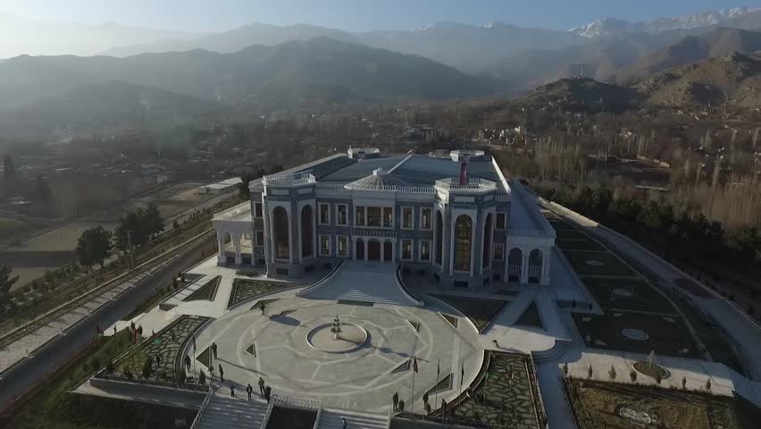
Paghman - City of Pashtuns and Tajiks
Paghman is a town in the hills near Afghanistan's capital of Kabul. It is the seat of the Paghman District which has a population of about 120,000, mainly Pashtuns and Tajiks. The gardens of Paghman are a major attraction making it one of the beautiful places to visit in Afghanistan and is why the city is sometimes known as the garden capital of Afghanistan.


Asadabad - Capital City of Kunar Province
Asadabad or Asad Abad is the capital city of Kunar Province in Afghanistan. It is located in the eastern portion of the country adjacent to Pakistan. The city is located within a valley at the confluence of the Pech River and Kunar River between two mountain ridgelines running along both sides of the valley from Northeast to Southwest. Asadabad is in a mountainous region of the Hindu Kush mountains about 13 km northwest of the Pakistani border and 80 km northeast of Jalalabad, Afghanistan.
Asadabad deals with a moderate amount of trade goods. Nawa Pass, that lies about 16 km south of Asadabad, is the next major border crossing point north of the Khyber Pass for the region. The pass is under constant observation due to its relative ease to cross for commerce and its potential usage for smuggling and Taliban insurgents.
Tigrovaya Balka Nature Reserve
Tigrovaya Balka Nature Reserve is in Tajikistan close to the Afghan border where the Vakhsh River and the Panj River join to form the Amu Darya. The reserve stretches over 40 km from the southwest to the northeast.
Pol-e-Khomri - Largest City of Baghlan Province
Puli Khumri, also spelled Pul-i-Khumri or Pol-e Khomri, is a city in northern Afghanistan. Located about 100 kilometers south of Kunduz, 200 kilometers southeast of Mazar-i-Sharif, and 230 kilometers north of Kabul, Puli Khumri is the capital and largest city of Baghlan Province, whose name comes from the other major town in the province, Baghlan. The city of Puli Khumri has a population of 221,274. It has 6 districts and a total land area of 3,752 hectares. The total number of dwellings in the city are 24,586.
Baghlan - City in Northern Afghanistan
Baghlan is a city in northern Afghanistan, in the eponymous province, Baghlan Province. It is located three miles east of the Kunduz River, 35 miles south of Khanabad, and about 500 meters above sea level in the northern Hindu Kush.
Langar - City on the Panj River
Langar is a village in the Wakhan District, Badakhshan Province in north-eastern Afghanistan. It lies on the Panj River, opposite the larger village of Langar in Tajikistan. The place should not be confused with a seasonal settlement called Langar, also in Wakhan, on the upper Wakhan River, some 130 km east.
Hairatan - Port in the North of Balkh province
Hairatan is a border town and a port in the north of Balkh province, Afghanistan. It sits along the Amu Darya river in the Kaldar district of Balkh province. The river forms the border with neighboring Uzbekistan, and the two nations are connected by the Afghanistan–Uzbekistan Friendship Bridge. The city of Termez in Uzbekistan is close to Hairatan. The altitude of Hairatan is 300m. Hairatan became one of the major transporting, shipping, and receiving location for Afghanistan.
Koh-i-Baba - City in South of Bamyan
The Baba Mountain range is the western extension of the Hindu Kush, and the origin of Afghanistan's Kabul, Arghandab, Helmand, Farah, Hari, Murghab, Balkh, and Kunduz rivers. The mountain range is crowned by Foladi peak rising 4951 m; 16,244 ft. above sea level, and is located south of Bamyan.
The Koh-i-Firoz plateau merges farther to the west by gentle gradients into the Paropamise, and which may be traced across the Hari River to Mashad. To the southwest of the culminating peaks, long spurs divide the upper tributaries of the Helmand River and separate its basin from that of the Farah River. These spurs retain a considerable altitude, for they are marked by peaks exceeding 11,000 ft. They sweep in a broadband of roughly parallel ranges to the southwest, preserving their general direction till they abut on the Great Registan desert to the west of Kandahar, where they terminate in a series of detached and broken anticlinals whose sides are swept by a sea of encroaching sand. The long, straight, level-backed ridges which divide the Argandab, the Tarnak and Arghastan valleys, and flank the route from Kandahar to Ghazni.
Behsud - Town in Maidan Wardak Province
Behsūd is a town in Maidan Wardak Province, central Afghanistan. It is the administrative center of Markazi Bihsud District. The town of Behsud has a population of 4,619.
Andkhoy - District in the Faryab Province
Andkhoy is a town and district in the Faryab Province of northwestern Afghanistan. The population of the town is 37,100. The district is located in the northern part of the province. The northern border is the national border with Turkmenistan. There is a road that leads it to the town of Kerki across the border, 100 km away.
Chagcharan - City in South of Hari River
Chaghcharān, also called Firuzkoh, is a town and district in central Afghanistan, which serves as the capital of Ghor Province. It is located on the southern side of the Hari River, at an altitude of 2,230 m above sea level.
Chaghcharan is linked by a 380 kilometers long highway with Herat to the west, and a 450 kilometers long highway with Kabul to the east. The town is served by Chaghcharan Airport. Chaghcharan has a population of about 15,000 who are mostly Dari speakers. However, the recent data showed a population of 31,266. it has 1 district and a total land area of 2,614 Hectares. The total number of dwellings in this city is 3,474.

Kholm - City in Inland Delta Fan of the Khulm River
Kholm or Khulm, also known as Tashqurghan, is a town until recently, in Samangan Province, and now in Balkh Province of northern Afghanistan 60 km east of Mazar-i-Sharif one-third of the way to Konduz. Kholm is an ancient town located on the fertile, inland delta fan of the Khulm River. As such, it is an agriculturally rich locale and densely populated. It is famous for its covered market and is a center for trading in sheep and wool. The town is slight to the south of the ruins of the ancient town of Aornos, destroyed in the mid-16th century.
Sarhad - Village in Wakhan in Badakhshan Province
Sarhadd or Sarhad, also known as Sarhad-e Broghil or Sarhad-e Wakhan, is a village in the Wakhan in Badakhshan Province in north-eastern Afghanistan. Sarhadd lies at an altitude of 3,400 m on the Wakhan River, at a point where the river broadens into a wide plain. It is inhabited by Wakhi people. The village lies at the end of a rough road from Ishkashim, and just to the north of the Broghil Pass. The population of the village is 548.
Maidan Shahr - City with Pashtuns
Maidan Shar, also Maidan Shahr or simply Maidan, is the capital of Maidan Wardak Province in central Afghanistan. Its population was estimated to be 35,008 in 2003, of which 85% are Pashtuns, and a smaller number of Hazaras and Tajiks forming the rest. The city of Maidan Shar has a population of 14,265. It has 4 districts and a total land area of 3,347 hectares. The total number of dwellings in Maidan Shar is 1,585.
Sar-E Pol - Capital City of Sar-E Pol Province
Sar-e Pol or Sari Pul is the capital city of the province of Sar-e Pol Province in northern Afghanistan. It is in Sari Pul District. In 2015, it had an official population of 51,075. There was 5,675 total number of dwellings in a total land area of 2,990 hectares.
Ab-i Istada - Endorheic Salt Lake in Nawa District
Ab-i Istada is an endorheic salt lake in Nawa District, Ghazni Province, Afghanistan. It lies in a large depression created by the Chaman Fault system in the southern foothills of the Hindu Kush, 125 kilometers south-southwest of Ghazni. In modern times the lake has been reported to have a surface area of 130 square kilometers, although it dries out periodically. It is very shallow, not exceeding 3.7 m in depth. There are two small islands near the lake's southeastern shore, Loya ghundai and Kuchney ghundai. The water is highly alkaline and mass die-offs of freshwater fish from the Ghazni River sometimes occur.
The main inflows into Ab-i Istada are the Ghazni, Sardeh and Nahara Rivers, which drain into it from the northeast. The watershed draining into the lake covers 17,252 square kilometers and was home to over 1.8 million people in 2003. Three sets of raised beaches surrounding the lake have been noted at 2–3 m, 6–7 m and 9–10 m above the normal lake level. At high water levels, the lake is known to overflow into the Lora River, a tributary of the Arghistan River, through two channels on the south side of the lake, Akasi Mandeh and Sekva Mandeh.
Yakawlang - Capital of Yakawlang District
Yakawlang was a city of 65,000 people in Yakawlang District, Bamyan Province, Afghanistan. It is the capital of Yakawlang District with an altitude of 2714 m. It was significantly destroyed by military forces in 2000-2001.

Pol-e Alam - Provincial Capital of Logar Province
Puli Alam, also spelled Pul-i-Alam or Pol-e Alam, is the provincial capital of Logar Province, Afghanistan as well as of Puli Alam District. The population of Puli Alam is estimated to be around 108,000, which is composed of ethnic Pashtuns and Tajiks. The city of Puli Alam has a population of 22,914. it has 4 districts and a total land area of 3,752 Hectares.
The total number of dwellings in this city is 2,546. Puli Alam has undergone massive reconstruction work after the fall of the Taliban government. A provincial reconstruction team PRT Logar of the Czech Republic was based in Puli Alam.
Punjab - Central Part of Bamiyan Province
Panjab district is in the central part of Bamiyan Province, Afghanistan. The capital is the town of Panjab. Panjab contains 5 valleys, the water running through the 5 valleys meet in the centre of the district. Its population is entirely Hazara people.
At 2,700 meters above sea level it has the highest altitude in the province, the city of Panjab is located 298 km from the capital Kabul - however, travel is difficult especially in winter - the journey takes 14 hours. Two rival parties, Pazdar and Hezb-e-Wahdat, dominate the district and have divided the district between them - there has been fighting between them.
Aqcha - Center of the Jowzjan Province
Aqcha or Akcha, is a town in northern Afghanistan. It is located approximately 50 kilometers east of Sheberghan and 100 kilometers west of Mazar-i-Sharif. It serves as the center of the Aqcha District of Afghanistan's Jowzjan Province. The town is situated a few kilometers north of the main Sheberghan-Mazar-i-Sharif road called Aqyol. The population of the town is around 50,000 people. The majority of which consists mostly of ethnic Turkmens and Uzbeks.

Aqcha is known for the traditional carpets and rugs that are made in the area. The predominant designs being the Turkmen, Bukhara and Fil Pah designs. At the beginning of the 19th century, Aqcha belonged to Bukhara, but in 1855 it was recovered by Dost Mohammed, when it became a khanate within the province of Afghan Turkestan. At the beginning of the 20th century, it was protected by a mud wall and a citadel, with an estimated population of 8000 people, chiefly Uzbeks. The Khanate was small, but well watered and populous.
Chishti Sharif District - Easterly District in Herat Province
Chishti Sharif District is the most easterly district in Herat Province, Afghanistan, situated along the Hari River and one of its northern tributaries. It borders with Obe District to the west, Badghis Province to the north and Ghor Province to the east and south. The population was estimated at 23,100 in 2012. The district administrative center is the village of Chishti Sharif.
Turkman Valley - Inhabited of Ethnic Hazara
Turkman Valley is a valley in Afghanistan located in Surkhi Parsa District of Parwan Province which is inhabited with ethnic Hazara.
So now you know the top places to visit in Afghanistan to relieve your senses and curiosity but take care of your safety and legal regulations ad it is also one of the most dangerous places to visit in the world.


No comments:
Post a Comment